LiDAR, or light detection and ranging, is a popular remote sensing method used for measuring the exact distance of an object on the earth’s surface.
After the introduction of GPS that it became a popular method for calculating accurate geospatial measurements.
LiDAR Technology
LiDAR uses a pulsed laser to calculate an object’s variable distances from the earth's surface.
These light pulses — put together with the information collected by the airborne system — generate accurate 3D information about the earth's surface and the target object.
There are three primary components of a LiDAR instrument — the scanner, laser, and GPS receiver. Other elements that play a vital role in the data collection and analysis are photodetector and optics.
Types of LiDAR Systems
Airborne LiDAR
Airborne LiDAR is installed on a helicopter or drone for collecting data. As soon as it’s activated, Airborne LiDAR emits light towards the ground surface, which returns to the sensor immediately after hitting the object, giving an exact measurement of its distance.
Airborne LiDAR is further divided into two types — Topological LiDAR and Bathymetric LiDAR.
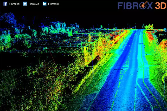
Terrestrial LiDAR
Unlike Airborne, Terrestrial LiDAR systems are installed on moving vehicles or tripods on the earth's surface for collecting accurate data points.
These are quite common for observing highways, analyzing infrastructure, or even collecting point clouds from the inside and outside of buildings. Terrestrial LiDAR systems have two types — Mobile LiDAR and Static LiDAR.
There are many lidar survey companies in India with capabilities to extract all the geospatial data for more than 100 used cases.
How Does LiDAR Work?
LiDAR follows a simple principle — throw laser light at an object on the earth's surface and calculate the time it takes to return to the LiDAR source. Given the speed at which the light travels (approximately 186,000 miles per second), the process of measuring the exact distance through LiDAR appears to be incredibly fast. However, it’s very technical. The formula that analysts use to arrive at the precise distance of the object is as follows:
The distance of the object = (Speed of Light x Time of Flight) / 2
There are many LiDAR projects in India. In addition to that, LiDAR can be used to accomplish many developmental objectives, some of which are;
1. Oceanography
the exact depth of the ocean’s surface to locate any object in the case of a maritime accident or for research purposes, they use LiDAR technology. LiDAR is also used for calculating phytoplankton fluorescence and biomass in the ocean surface.
2. Digital Elevation or Terrain Model
Terrain elevations play a crucial role during the construction of roads, large buildings, and bridges. LiDAR technology has x, y, and z coordinates, which makes it incredibly easy to produce the 3D representation of elevations.
Which is also famous as Scan to BIM. However, Scan to BIM service providers in India is taking care of international projects also due to different valuation of a currency.
3. Agriculture
Typical applications of LiDAR technology in the agriculture sector include analysis of yield rates, crop scouting, and seed dispersions. Also, campaign planning, mapping under the forest canopy, and more.
4. Surveying
LiDAR surveying is used in the fields of construction, urban planning, and examining the topography of a region. LiDAR surveying collects data very fast and thus is superior to conventional forms of surveying. Spatial models created using LiDAR have a negligible scope of error margin, save a considerable amount of money and improve the final decision making. In surveying, point data is converted into a surface, or Digital Elevation Model (DEM). The DEM can be of any texture depending on the application and density of the data. After the surface is created, analysis can be done, as required.
5. Archeology
LiDAR is proving to be an important asset especially because of extraordinary detailing that it offers. LiDAR saves time as well as the effort of the archeologists and allows them to create models that were almost impossible to create earlier. Stunning 3D images of an ancient Mayan city were created by two archeologists using LiDAR which offers unprecedented insight into that ancient city.
6. LiDAR in Augmented Reality (AR)
A LiDAR scanner offers high-quality 3D mapping, which permits other AR systems to stack data on top of a high-resolution map. Using point cloud, LiDAR adds to the AR experience. A very useful in aviation safety, atmospheric data visualizations, weather forecasting, and disaster preparedness.
7. LiDAR in autonomous vehicles
LiDAR should be called the eye of an autonomous vehicle as it looks at the surroundings of the vehicle, calculates distance, identifies obstructions ahead, illuminates objects with a laser, and then creates a high-resolution digital image. LiDAR is also used to avoid collisions by measuring the distance between a car and any other car in front of it. This is done by mounting a LiDAR on the bumper or the roof. The Adaptive Cruise Control system in an autonomous car gets the information from the LiDAR sensors, using which it decides when to apply the brakes, slow down, or accelerate.
8. LiDAR in climate change mitigation
The ultra-high resolution and precise imagery of LiDAR capture and highlight even the minutest details. LiDAR can help track deforestation and agriculture patterns more efficiently than any other method. And the data obtained also pinpoints what was left unobserved in previous estimations, which makes it all the more reliable.
Know more:
- Which is best Photogrammetry or 3D Scanning ?
